History
This information has been aggregated from multiple publicly accessible sources.
For alternative information or amendment requests, please share your feedback.
Forged by Pioneer Roots, Rails, and Resilience:
A History of the Battlemont Neighborhood
Introduction: A Layered Legacy
Though the name Battlemont was formally adopted in 1998 when local residents established the neighborhood association[14, 15], the history of this land spans more than a millennium[3]. Situated three miles south of downtown Nashville, Battlemont encompasses a 16+ block historic residential area bounded by Interstate 440 to the north, Granny White Pike to the west, Woodmont Boulevard to the south, and Brown's Creek to the east[5].
Prior to the completion of Interstate 440 in 1987, this area was known as Woodmont-East, sharing a continuous urban fabric with the Belmont-Hillsboro neighborhood[5, 8]. When highway construction physically separated these blocks, residents united to preserve their community, deriving the name "Battlemont" from two historic boundary thoroughfares: Battlefield Drive and Woodmont Boulevard[14, 15].
Today, Battlemont stands as a living tapestry of Middle Tennessee history—from an ancient Mississippian stone-grave metropolis to pioneer land grants, a pivotal Civil War battlefield encampment, an early streetcar suburb, and a textbook post-WWII "GI Bill" residential community[1, 3, 4, 10, 12].
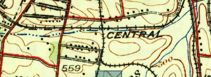
The 1932 USGS Nashville Quadrangle map illustrating the Battlemont corridor, showing the Glendale Trolley line along Lealand Lane, early homes along Noelton and Clifton, and Woodmont Boulevard prior to its continuous extension[11].
1. Ancient Origins: The Mississippian Culture & "Noel Cemetery"
Long before European settlement, the land along Brown's Creek was the site of a major prehistoric Native American metropolis during the Mississippian period (circa 1000–1450 AD)[3].
In 1888, during grading for the Glendale Park Streetcar Line on Oscar F. Noel's farm, workers uncovered one of the largest aboriginal burial grounds in North America, historically known as the Noel Cemetery (site 40DV3)[3]. Archaeological investigations revealed between 3,000 and 4,000 stone-box graves (cists) lined with limestone slabs, alongside elaborate pottery and ceremonial artifacts[3].
Subsequent discoveries continued throughout the 20th century, including a 10-acre palisade site uncovered in 1967 near Clifton Lane and Granny White Pike, and a 1973 excavation by the Tennessee Division of Archaeology that uncovered palisade wall structures and stone-box graves dating to A.D. 1220 ± 45[3]. The northern boundary of this ancient settlement extends directly into the heart of modern Battlemont[3].
2. Pioneers & Early Estates: The Ewing and McNairy Legacies
The written property records of Battlemont trace back to a 1792 Revolutionary War land grant issued to Andrew Ewing (1742–1813), a signatory of the Cumberland Compact, Davidson County Court Clerk, and early Nashville pioneer[1]. Andrew Ewing conveyed the farm to his son, Nathan Ewing (County Court Clerk 1813–1830), who established his family home here[1, 2].
In his May 1830 will, Nathan Ewing explicitly set aside a half-acre tract on his farm as a perpetual burial ground for his posterity[2]. Today, the Ewing Cemetery, located at 1016 Woodmont Boulevard, remains a legally designated, protected historic plot containing the resting places of pioneer descendants[2].
Further east along Woodmont Boulevard, the land comprised the 251-acre farm known as "Vinegar Hill," owned by Francis "Frank" Nathaniel McNairy, who served during the Civil War era[7].
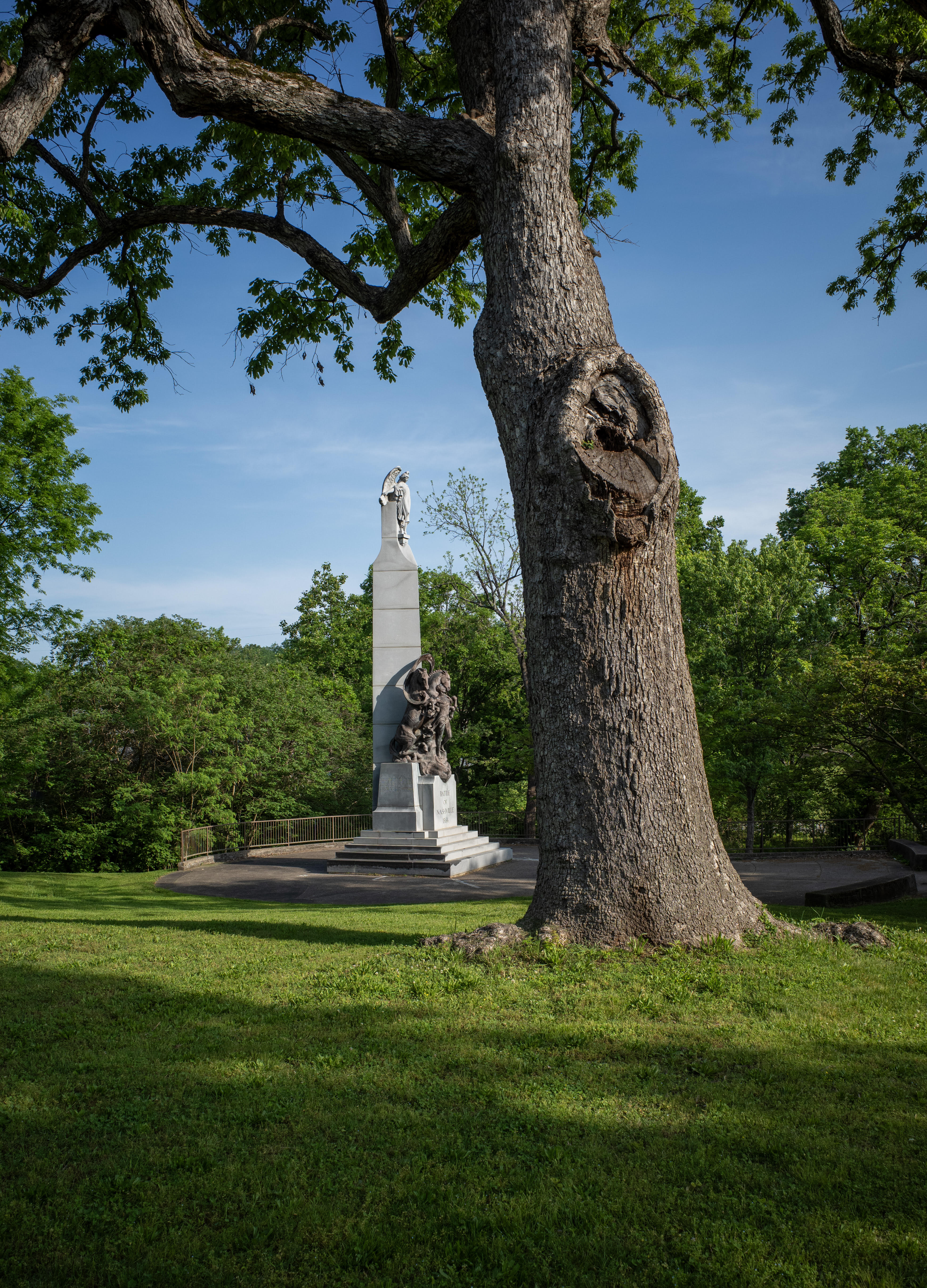
The Battle of Nashville Peace Monument, erected in 1927 and relocated in 1999 to Battlefield Park (Clifton Lane & Granny White Pike) beneath a certified Civil War Witness Tree (Photo by neighbor Peyton Hoge)[4, 13].
3. Civil War Crucible: The Battle of Nashville (December 1864)
Battlemont sits on core battlefield terrain between Union and Confederate main lines during the Battle of Nashville[4, 13].
On December 2, 1864, General Edward "Allegheny" Johnson's Confederate Division (comprising over 2,400 soldiers) arrived and encamped across the footprint bounded by Granny White Pike, I-440, Woodmont Boulevard, and McNairy Lane[4]. For 14 days, the troops endured a severe, debilitating ice storm without campfires to avoid attracting Union artillery fire[4].
When heavy fighting erupted on December 15, 1864, U.S. General Thomas J. Wood's forces advanced across present-day Belmont and Granny White Pike, sweeping into Battlemont[4]. Severe skirmishing occurred across these hills; Confederate General Claudius Wistar Sears was severely wounded near modern Crestridge Drive and Woodmont Boulevard[4].
Today, this military legacy is commemorated at Battlefield Park (Clifton Lane & Granny White Pike), home to the Battle of Nashville Peace Monument (sculpted by Giuseppe Moretti in 1927) and a certified Civil War Witness Tree[4, 13]. Two additional certified Witness Trees—historic Bur Oaks that stood during the 1864 battle—are preserved at 950 Battlefield Drive (Lealand Lane & Battlefield Drive)[13].
4. The Streetcar Era: O.F. Noel & the Glendale Trolley Line
In 1880, flour and grain magnate Oscar Fitzallen (O.F.) Noel purchased 190 acres of the former Ewing/Gale estate and established his grand country manor, "Noelton"[6, 15]. O.F. Noel was a prominent business leader—founder of Cumberland Milling Company, co-founder of the Fourth and First National Bank, and President of the Cumberland Telephone & Telegraph Company[6].
To stimulate residential development south of Nashville, O.F. Noel teamed with neighboring landowner James E. Caldwell (owner of the Longview estate) to form the Waverly Land Company[6, 7]. In 1887, they opened the Glendale Park Streetcar Line—a steam "dummy" engine line that ran directly through Battlemont along present-day Lealand Lane to Glendale Park, Nashville's first zoo and amusement park[6, 7, 10].
The Glendale Trolley operated until 1932, serving as the primary catalyst for Battlemont's emergence as an early streetcar suburb[6, 10]. Many residential lots along Lealand Lane still retain physical corridor remnants of this historic transit line[6, 11].
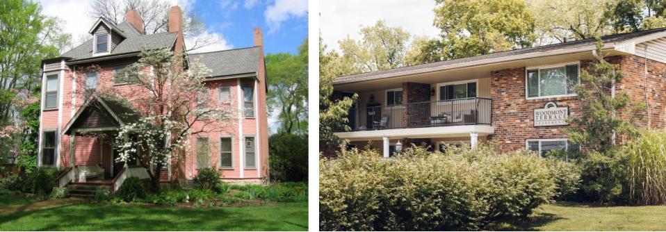
Left: The Mulberry House (1100 Clifton Lane, built 1876), a Princess Anne Victorian home designated as a Neighborhood Landmark Overlay[9, 15]. Right: Woodmont Terrace Apartments (920 Woodmont Blvd, built 1938–1939), listed on the National Register of Historic Places[7].
5. Architectural Landmarks & Notable Residents
From turn-of-the-century Victorian manors to landmark multi-family complexes, Battlemont features an extraordinary range of intact historic architecture:
- The Mulberry House (1100 Clifton Lane, built 1876): The oldest standing structure in Battlemont, this Princess Anne Victorian home features spindle work, turrets, and a wrap-around porch[9, 15]. Protected under a Metro Neighborhood Landmark Overlay (BL2005-603)[9].
- Woodmont Terrace Apartments (920 Woodmont Blvd, 1938–1939): Designed by renowned architect Edwin Keeble (Warfield & Keeble) on James E. Caldwell's former land, this 11-building Colonial Revival complex was Nashville's first garden apartment development and is listed on the National Register of Historic Places[7].
- MidTown Fellowship "Manse" (3410 Granny White Pike, 1906): Built as a Georgian Colonial Revival stone residence for engineer Martin S. Roberts Sr. (co-founder of Hart, Freeland & Roberts, the firm that renovated the Parthenon and Ryman Auditorium)[15].
- 1108 Clifton Lane (built 1913): Constructed for Andrew Mizell Burton, founder and 48-year president of Life & Casualty Insurance Company (builder of the downtown L&C Tower)[6, 15].
- 1021 Clifton Lane (built 1899): Longtime residence of Charles A. Howell III, Tennessee Commissioner of Conservation, charter Metro Councilmember (1962), and first Executive Director of Historic Nashville Inc., who led efforts to save Union Station and Second Avenue[15].
- 1029 Noelton Avenue (built 1936): A historic log cabin reassembled in Colonial Revival style for Catherine Noel and Charles Anderson by Hart, Freeland & Roberts; later owned by hall-of-fame songwriter John D. Loudermilk (author of "Tobacco Road")[15].
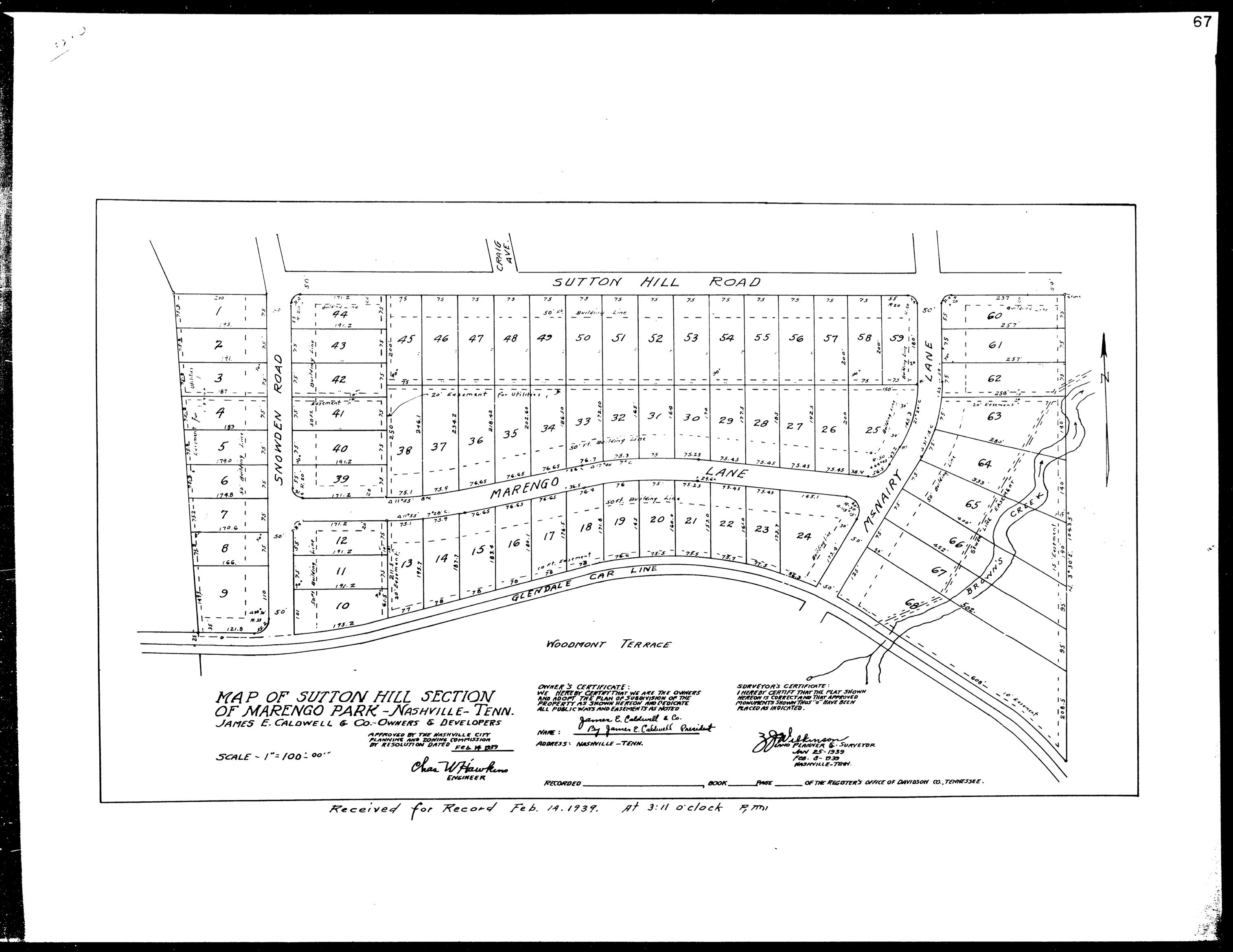
The 1939 subdivision plat for the Sutton Hill Section of Marengo Park, developed by C.B. Kelley to provide affordable post-war housing for returning WWII veterans[10, 12].
6. The Post-WWII Housing Boom: C.B. Kelley & "GI Bill" Subdivisions
While Battlemont contains significant early 20th-century homes, nearly 70% of its residential character was established between 1940 and 1959 during the national post-World War II housing boom[10, 12].
East of Lealand Lane, three distinct, contiguous platted subdivisions were built on land purchased from the O.F. Noel estate[10, 12]:
- Battlefield Estates (Platted 1935): 69 original homes[10].
- Marengo Park / Sutton Hill Section (Platted 1939): 78 original homes[10].
- Pleasant Valley (Platted 1948): 85 original homes[10].
These subdivisions were built by prominent Nashville developer C.B. Kelley, Chairman of the Chamber of Commerce Post-War Housing Committee[12]. Designed to meet urgent housing needs for veterans returning from WWII under the GI Bill, these "Kelley-built" homes embody Minimal Traditional, Tudor Revival, and early Transitional Ranch styles[12].
Common architectural features across these post-war blocks include six-over-six divided-light windows, local limestone foundations, solid wood entry doors, clipped gables, dormers, and half-timbering accents[12].
7. Chronological Historical & Architectural Summary
| Era / Date | Historical Event & Architectural Milestone | Reference |
|---|---|---|
| c. 1000–1450 AD | Mississippian stone-grave metropolis along Brown's Creek ("Noel Cemetery" site 40DV3). | [3] |
| Feb 8, 1792 | Land grant issued to pioneer Andrew Ewing; later conveyed to Nathan Ewing. | [1] |
| May 13, 1830 | Nathan Ewing's will establishes the 0.5-acre Ewing Family Cemetery at 1016 Woodmont Blvd. | [2] |
| Dec 2–16, 1864 | Gen. Edward Johnson's Confederate Division encamps in Battlemont; Battle of Nashville fought. | [4] |
| 1876 | Construction of the Mulberry House (1100 Clifton Lane), oldest home in Battlemont. | [9, 15] |
| May 7, 1880 | Oscar Fitzallen Noel purchases 190 acres and establishes the "Noelton" estate. | [6, 15] |
| 1887–1932 | Glendale Park Streetcar Line operates along Lealand Lane, spurring streetcar suburb growth. | [6, 10] |
| 1906 | Engineer Martin S. Roberts Sr. builds stone manse at 3410 Granny White Pike. | [15] |
| 1927 / 1999 | Battle of Nashville Peace Monument erected; relocated to Battlefield Park beneath Witness Tree. | [4, 13] |
| 1935–1948 | C.B. Kelley plats Battlefield Estates, Marengo Park, and Pleasant Valley for post-war housing. | [10, 12] |
| 1938–1939 | Woodmont Terrace Apartments constructed; listed on National Register of Historic Places. | [7] |
| 1987 | Interstate 440 completed, severing Woodmont-East from Belmont-Hillsboro. | [5, 8] |
| 1998 | Battlemont Neighborhood Association officially formed, adopting the name "Battlemont." | [14, 15] |
References & Primary Sources
- Davidson County Land Grant Records & Deed Registers: Andrew Ewing 1792 Land Grant (Davidson County Book A, p. 142); Nathan Ewing Deed Records.
- Davidson County Probate Court Records: Nathan Ewing Last Will and Testament, dated May 13, 1830 (Will Book 9, p. 412), establishing the Ewing Family Cemetery at 1016 Woodmont Blvd.
- Tennessee Archaeology Network & State Archaeological Reports: Kevin Smith (MTSU), Re-envisioning the Noel Stone-Grave Cemetery Site (40DV3), Tennessee Archaeology Council Research Series.
- U.S. War Department Archives & Military Surveys: The War of the Rebellion: A Compilation of the Official Records of the Union and Confederate Armies, Series I, Vol. 45 (Battle of Nashville Encampment Maps & After-Action Reports).
- Metropolitan Historical Commission Publications: Nashville: Conserving a Heritage (1977), designating the Woodmont-East historic residential corridor.
- Ridley Wills II Historical Monographs: Nashville Pikes: Volume One — 150 Years along Franklin Pike and Granny White Pike (2018), documenting Noelton, Longview, and early estate developments.
- National Park Service — National Register of Historic Places: Woodmont Terrace Apartments Registration Form (NPS Form 10-900, Listed April 2002), 920 Woodmont Blvd.
- National Park Service — National Register of Historic Places: Belmont-Hillsboro Historic District Nomination Form (NPS Form 10-900, Listed May 1980).
- Metropolitan Nashville Council Legislation: Ordinance BL2005-603, establishing the Neighborhood Landmark Overlay for the Mulberry House (1100 Clifton Lane).
- Davidson County Register's Office Subdivision Plats: Map of Battlefield Estates (Plat Book 97, p. 13, 1935); Map of Sutton Hill Section of Marengo Park (Plat Book 102, p. 14, 1939); Map of Pleasant Valley (Plat Book 118, p. 15, 1948).
- U.S. Geological Survey Topographic Maps: Nashville Quadrangle, 7.5-Minute Series (Topographic), 1932 Edition (Tennessee Virtual Archive / TEVA).
- Nashville Public Library — Special Collections: Nashville Electric Service (NES) & Nashville Railway & Light Co. Public Relations Records (Finding Aid 2004.022); Metro Historical Commission Post-War Homes Architectural Survey.
- Battle of Nashville Preservation Trust Records: Battlefield Park Witness Tree Certification & Peace Monument Relocation Survey (1999/2018).
- Battlemont Neighborhood Association Organizational Charter: BNA Incorporation Minutes and Founding Charter (1998).
- Battlemont Neighborhood Historical Archives: Research files, land title abstracts, and oral histories compiled by Kira Hilley, BNA Steering Committee, and Local Historians (2026).